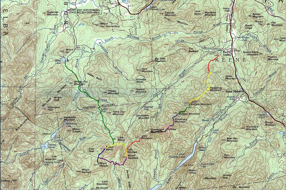
2/01: we attempted to ski the traverse in winter and failed.
* * *
Route Maps are contained in the dropdown below (note the image sizes - maps are large):
click the image below for a full-size map (513k).
the traverse is almost entirely above 4000 feet.
skiing the traverse is a very dumb idea.
the great range traverse:
2/02: we attempted to slog the traverse in winter and failed.
9/02: we did the thing in a day in fall and pledged to never speak of it again.
|
ranking by height (adk range) |
mountain | elevation |
| approach | Roostercomb to Hedgehog | 3369 |
| 30 | Lower Wolfjaw | 4175 |
| 29 | Upper Wolfjaw | 4185 |
| 22 | Armstrong | 4400 |
| 10 | Gothics | 4736 |
| 17 | Saddleback | 4515 |
| 9 | Basin | 4827 |
| col | Little Haystack | |
| 3 | Haystack (variation) | 4960 |
| 1 | Marcy | 5344 |
route notes:
route length:
logisitics:
bivy sites:
recommended sites follow:
bivy icons are included on the fullsize west overview map.
it's a very good idea to have a third day built in for weather, etc.
committment:
there are two long, steep descents that in bad or icy conditions may require a rappel for safety. for more info, check the route profiles and maps and read the trail descriptions in the ADK High Peaks guidebook. you'll notice that the book strongly recommends against trying the traverse in winter.
* * *
Route Maps are contained in the dropdown below (note the image sizes - maps are large):
note the haystack variation. it is also possible to carry over haystack and cross panther gorge, summit skylight (if very motivated), then carry over marcy from the south. see notes below.
on our first attempt, we were shooting for, but got nowhere near, the following (on our second attempt we did a little better):
camping above 4000 feet is permitted in the daks between dec. 15 and april 30. i would recommend two to three days to complete the route with two likely bivies. certainly one bivy will take place on the great range trail (on the ridge). several bivy spots exist on the ridge in various cols between peaks.
![]() = ideal bivies
= ideal bivies
![]() = possible/emergency bivies
= possible/emergency bivies
once on the ridge proper, bailing is gets more complicated after lower wolfjaw. the point of no return is the col between gothics and saddleback. there is one escape route here and one before, at lower wolfjaw. i can only see this being a concern in bad weather or very poor snow conditions. the ridge biv(ies) can be exposed and it's a good idea to limit your time on the ridge to one and a half days if possible. the most difficult extended section is armstrong to basin.